A reader recently sent a note that reminded me of one of the most fascinating subjects I can think of: Manhattan’s underground rivers and streams. (If any other readers have interesting tidbits to share, please feel free do so!)
Over a century ago, before the island at the center of New York City was flattened and covered in asphalt, Manhattan was a fairly soggy place. Much of downtown was marshland, and dozens of creeks and small rivers trickled all over town.
As the city grew, ponds and swamps were drained, and New York’s streams were buried beneath its streets. But these “subterranean waterways” never dried up. They’re still there, flowing beneath our feet. (A good sign that you’re near one is the presence of a weeping willow tree.) There’s only one problem: very few people today know where they are. And if you start building on top of a forgotten spring, you’re going to end up with nothing more than a damp pile of bricks.
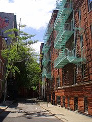
Fortunately, there’s a map that can tell you where to find all of Manhattan’s invisible waterways. Created by an engineer named Egbert Ludovicus Viele and first used in 1874, the “Sanitary & Topological Map of the City and Island of New York” (otherwise known as the Viele Map) has been the saving grace of countless developers. Over five feet long and remarkably detailed, it shows all the rivers, streams, and ponds that no one has seen in a over a hundred years. (Including Minetta Creek, which flows under the street pictured above!)
Click here for a closer look at the map or—if you have a spare $15,000—to buy a copy.
2 comments:
Wow. I'm surprised they put those up for the public to look at... couldn't someone easily steal it?
I was born in Syracuse New York and
raised in North Syracuse and Clay
both in Onondaga County. In the Central New York area are a lot of underground rivers that are connected to Oneida Lake and Lake Ontario. Some of these underground rivers have dried up and left humongus caves. Some of these caves were used by the CIA for spying I have seen them as a teenager back in the 1950's.
You won't beleive this but one of these caves my father took me to had a big old steam engine sitting right in the middle of it no railroad tracks.
During WWII in Oswego County a farmer had a big pond on his farm and it was well known the pond did not have a bottom to it. Well one day the farmer went out to work in the field as he was going by this pond he discovered a small German submrine in the middle of the pond. It held about six or eight men. They figured the submarine entered Lake Ontarieo from the
St. Lawrence River and than entered into this underground river. royclementjr@gmail.com
Post a Comment